


The data sources providing information of raster type are raster files and the WMS, WCS and ArcIMS Map services. The 3D views allow representing the raster data in two ways: as images (flat over the terrain surface) and as elevation (defining the terrain relief).
The 3D extension offers to the user the option to represent a raster as elevation in the following cases:
- For raster files, when they only have one band (normal situation with digital terrain models - DTM’s).
- For WMS services, when the TIFF or geoTIFF formats are selected. In the case the raster is to be used as elevation, it would be necessary to choose a style allowing for those values, usually indicated as "integer", "unsigned int", or 16 (or more) bits per pixel.
- For WCS services, when the GEOTIFF_INT16 is selected and there are no parameters (bands) selected.
In the case that is possible to use the raster as elevation the following dialog will appear:
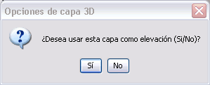
Loading option dialog of layer as elevation layer.
Only one elevation layer will accepted in each 3D view. If the user tries to add additional layers to the view the following message will appear:
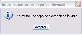
Control of additional elevation layers dialog.
At the moment gvSIG is able to reproject rasters, therefore there should not be any problem using layers with different reference systems to the view.


